Showing 452 items matching plan of survey
-
 Federation University Historical Collection
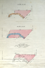
Plan, Plan of Survey Crown Allotment 9A and Part of Crown Allotment 8 Section 10 City and Parish of Ballaarat, after 1929
... Plan of Survey Crown Allotment 9A and Part of Crown...plan of survey... Plan Plan of Survey Crown Allotment 9A and Part of Crown ...ink and watercolor on watermarked laid paper dated 1928text and measurementsballaraat, ballarat, plan, plan of survey, armstrong street, skipton street -
 Ringwood and District Historical Society
Article - Newspaper Clipping, Land Sale Advertisements, Golden Hill Estate, Ringwood - 1965, 1966, and Plan of Survey of Lot 8, Mullum Mullum Road Ringwood, 1970. 1970
... - 1965, 1966, and Plan of Survey of Lot 8, Mullum Mullum Road..., and Jacynthe Court. Includes subsequent 1970 surveyor's Plan of Survey..., Melbourne. (Phone) 26-2443, A.H. 850-2195. Plan of Survey signed..., and Plan of Survey of Lot 8, Mullum Mullum Road Ringwood, 1970 ...Newspaper clippings from Melbourne Sun newspaper (11th December 1965 and 15th January 1966) advertising sale of land - Golden Hill Estate, Ringwood, with summary of features and aerial photograph including artistic representation of street layout. Streets depicted in the esate diagram include Mullum Mullum Road, Sonia Street, Jill Court, Linda Drive, Eve Court, Alma Court, and Jacynthe Court. Includes subsequent 1970 surveyor's Plan of Survey of Lot 8 Mullum Mullum Road Ringwood, LP 67513, Cert of Title 8581/429.Agent - Aaron, King & Co., Suite 2, 33 Queens Road, Melbourne. (Phone) 26-2443, A.H. 850-2195. Plan of Survey signed on 25.7.1970 by Roger M. Gamble, Land Surveyor, 28 Summit Crescent, Ringwood 3134. -
 Melbourne Tram Museum
Drawing, "Plan of Survey of Part of Crown Allotments 15 and 16 at Hawthorn, Parish of Boroondara, County of Bourke", 1922
... "Plan of Survey of Part of Crown Allotments 15 and 16 at... "Plan of Survey of Part of Crown Allotments 15 and 16... drawing wash, titled "Plan of Survey of Part of Crown Allotments ...Drawing, coloured with water based drawing wash, titled "Plan of Survey of Part of Crown Allotments 15 and 16 at Hawthorn, Parish of Boroondara, County of Bourke". Shows the tram track, Wallen Road, changes around the intersection with Power St, buildings. A note at the bottom notes who owns what - MMTB and City of Hawthorn. Prepared by H. S. McComb, licensed Surveyor 6-9-1922. Stored folded.Stamped "Drawing Office" "Office Copy" and in red pencil "Hawthorn" in the bottom right hand corner, and on the rear "Drawing Office" "Office Copy" and "Hawthorn Depot" in pencil.trams, tramways, htt, mmtb, hawthorn depot, plans -
 Whitehorse Historical Society Inc.
Map, Plan of special survey selected by H. Elgar Esq, 1841
... Plan of special survey selected by H. Elgar Esq.... Note on verso: Plan of special survey selected by H... on verso: Plan of special survey selected by H. Elgar Esq... Mitcham melbourne Map Map Plan of special survey selected by H ...Photocopy of plan and listing of corner stakes.Photocopy of plan and listing of corner stakes. Note on verso: Plan of special survey selected by H. Elgar Esq in the Parishes of Boroondara and Nunawading, County of Bourke. Surveyed by T.H. Nott (?Sydney) 31 May 1841. Boroondara Special Survey B.17, with attached descriptive note by T. H. Nott.Photocopy of plan and listing of corner stakes. maps, parish of boroondara, parish of nunawading, elgar, h, nott, t.h. -
 Federation University Historical Collection
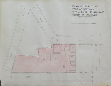
Plan, Plan of Survey of Part of Section 9A City & Parish of Ballarat County of Grenville (Albert Street frontage), 1932
... Plan of Survey of Part of Section 9A City & Parish of... Plan Plan of Survey of Part of Section 9A City & Parish ...The M.B. John Trade Building was built on the Albert Street Frontage..1) Plan of SMB showing Albert, Grant, Lydiard and Dana streets, on paper with colored highlights undertaken by Ballarat School of Mines student George Murrowood in 1932 .2) Hand written page by George Murrowood, of technical description of land surveying Grade II 1932ballarat school of mines, surveying, george murrowood, albert street, alumni, m.b. john building, architectural plan -
 Tatura Irrigation & Wartime Camps Museum
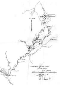
Map - Map - Photocopy, New Guinea Escape Route
... Plan of surveyed route from Edie Creek to Bulldog Drome... Photocopy of New Guinea map showing escape route Plan of surveyed ...At the end of January 1942 there was only about 250 men left in Wau, as the women and children had been evacuated by air a little earlier. With no planes to take the men they had to make their own way to Port Moresby and then travel by ship to Australia. Some men went down to Salamaua and made their way along the north coast, but small groups also made their way over the Owen Stanley Ranges; rafting down the Lakekamu RIver to Yule Island and by boat to Port Moresby. Donor Vanessa Kiessling's Father was part of the second group, and had drawn a detailed map of their route. This might be the same route taken by Rev. Willi Hertle (Ref C0750)Photocopy of New Guinea map showing escape routePlan of surveyed route from Edie Creek to Bulldog Dromepapua new guinea, escape, map, wau, willi hertle, kiessling -
Stawell Historical Society Inc
Map, Gold Mines of Australia, Gold Mines of Australia underground workings. Newington Rd Darlington Rd Area 1950, 1950
... Plans Showing Surveys & Drilling Stawell Investment.... Newington Rd Darlington Rd Area 1950 Plans Showing Surveys ...Plans Showing Surveys & Drilling Stawell InvestmentGold Mines of Australia Stawell Investment 2003 mining, gold, map -
 Warrnambool and District Historical Society Inc.
Documents, Swintons Paper att 18/53 Merri St. Contract. Map. Notes, 1959
... .2 ‘Plan of Survey of Part of Crown Allotment 18 Section 3... handwritten material (a letter) in blue ink. .2 ‘Plan of Survey ...These documents relate to the sale of land in Merri Street Warrnambool in 1959 by Swintons Pty Ltd of Warrnambool. The buyer of the land was George O’Grady, a Warrnambool baker. The land sold for £4000 and there was a shed on the land (called the ‘Office’) which George O’Grady indicated he wished to be included in the sale. William and Ann Swinton migrated to Australia in 1854 and for a decade William Swinton worked as a builder and carpenter in the Warrnambool area, erecting many buildings, including the Wangoom Presbyterian Church. In 1865 he opened a store in Timor Street Warrnambool, selling groceries, hardware, china and glassware. By 1888 the business was known as William Swinton and Sons. Branch stores were opened in Wangoom, Cudgee, Nullawarre, South Warrnambool and West Warrnambool. After William Swinton died his son Robert became the first managing director of Swintons Pty Ltd. In 1934 the business split with George Swinton and Sons selling clothing, furnishings and glassware and Swintons Pty Ltd selling seeds, produce and hardware. Today the Swinton family still operates a furniture and bedding shop in Timor St Warrnambool.These items are of some interest as being connected to the Warrnambool business of Swintons Pty Ltd. They will be of interest to researchers. The current Swinton business in Timor Street is the oldest family business in Warrnambool and, with the name Swinton associated with businesses in Timor Street Warrnambool for 152 years it is amongst the oldest family businesses in Australia.The items here relate to the sale of land by Swintons Pty Ltd., Warrnambool. .1 These are three pages of white paper with typed material, a lawyer’s signature in blue ink, one green stamp and a sketch of the land location. .2 This is a sheet of thick paper containing a plan of the land sold. The paper has printed material and a sketch of the land with part of it coloured in pink. .3 This is a small piece of paper torn at the bottom right edge. It has handwritten material (a letter) in blue ink..2 ‘Plan of Survey of Part of Crown Allotment 18 Section 3 Township of .2 ‘Plan of Survey of Part of Crown Allotment 18 Section 3 Township of Warrnambool Parish of Wangoom County of Villiers’ .3 ‘Tuesday Dear Mr Swinton I am writing to say that I would like to have the ‘Office’ Thanking You George O’Grady’swinton family,, warrnambool -
Southern Sherbrooke Historical Society Inc.
Map - photocopy
... A3 photocopy of plan of survey of part of Crown Allotments... - photocopy A3 photocopy of plan of survey of part of Crown Allotments ...A photocopy taken from the original land sale map provided to the society through Karel Coxell of Stockdale & Leggo. The original maps are stored in large bound account books and were originally the propert of McNally Real Estate. The books are held (in 2A3 photocopy of plan of survey of part of Crown Allotments 20 & 21, section C, parish of Narre Worran, County of Mornington. Clements Ave and environs in Belgrave Heights"Villette Estate" in top LH corner, "Locality Plan" in bottom LH corner, "Not in sale" written on one block and crossed out. All handwritten in pencil on original. "Colby Drive " and "Verona Street" added in pencil to copy.land sales, advertisements, subdivision -
Whitehorse Historical Society Inc.
Document, Division of Survey and Mapping, 1984
... Information guide to Parish and Township Plans - Division... Information guide to Parish and Township Plans - Division of Survey ...Information guide to Parish and Township Plans - Division of Survey and Mapping - Victorian Government..Information guide to Parish and Township Plans - Division of Survey and Mapping - Victorian Government..Information guide to Parish and Township Plans - Division of Survey and Mapping - Victorian Government..crown lands, victorian government, land surveys -
Whitehorse Historical Society Inc.
Map, Burwood Road, Box Hill City, 15/02/1952 12:00:00 AM
... as Survey Plan No 5441.... between Milford Avenue and Station Street. Marked as Survey Plan... Avenue and Station Street. Marked as Survey Plan No 5441. Between ...Plan of subdivision of ten blocks in Burwood Road, Burwood.Plan of subdivision of ten blocks in Burwood Road, Burwood between Milford Avenue and Station Street. Marked as Survey Plan No 5441.Plan of subdivision of ten blocks in Burwood Road, Burwood. land subdivision, burwood road, burwood, milford avenue, burwood, central court, burwood -
Whitehorse Historical Society Inc.
Map, Burwood Road, Box Hill City, 15/02/1952 12:00:00 AM
... as Survey Plan No 5442....Plan of subdivision of 19 blocks in Burwood Road, Burwood... Street and Middleborough Road. Marked as Survey Plan No 5442 ...Plan of subdivision of 19 blocks in Burwood Road, Burwood.Plan of subdivision of 19 blocks in Burwood Road, Burwood between Greenwood Street and Middleborough Road. Marked as Survey Plan No 5442.Plan of subdivision of 19 blocks in Burwood Road, Burwood. land subdivision, burwood road, burwood, greenwood street, burwood, middleborough road, burwood -
 Kew Historical Society Inc
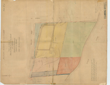
Plan, Survey Plan, Park Hill Road, Kew, 1880-1890
... Survey Plan, Park Hill Road, Kew...The streets identified on the survey plan - Cotham Road...Hand drawn and coloured survey plan created by Holland... Plan Survey Plan, Park Hill Road, Kew Hand drawn and coloured ...The streets identified on the survey plan - Cotham Road, Park Hill Road East, Park Hill Road West in Kew were each gazetted by the Victorian Government in 1865. The hand-coloured survey plan was completed by Holland Loxton, Town Clerk and Surveyor of the Borough of Kew from 1866. The unnamed survey plan includes names of land owners in addition to measurements (2 chains to 1 inch) and streets. Named owners include Webster, Payne and Francom which will enable us to narrow down the creation date of the survey.Handdrawn survey plan by a former surveyor and town clerk of KewHand drawn and coloured survey plan created by Holland Loxton, Surveyor and Town Clerk of Kew, showing land owned by Payne in Park Hill Road, Kew. The plan includes street names, land measurements and land owners.surveys - kew, maps - kew, holland loxton, park hill road - kew, holland loxton -- surveyor, survey plans -- parkhill road -- kew (vic.) -
University of Melbourne, Burnley Campus Archives
Plan, Detail Plan of Victoria Park, 1976
... . Survey Plan, Sheet 1 of 2 by Alan Baker, Terry Martin, Richard... Swinburne College of Technology Ltd. Plan dated July 1976. Survey ...Swinburne College of Technology Ltd. Plan dated July 1976. Survey Plan, Sheet 1 of 2 by Alan Baker, Terry Martin, Richard Yeoman.swinburne college of technology, alan baker, terry martin, richard yeoman -
Whitehorse Historical Society Inc.
Map, Subdivision of Allotment 122a, 1972
... on this plan is in proclaimed survey No 21. Survey Coordination Act... 'Land on this plan is in proclaimed survey No 21. Survey... on this plan is in proclaimed survey No 21. Survey Coordination Act ...Subdivision of land along Livermore Close and Moore Road, Vermont South.Subdivision of land along Livermore Close and Moore Road, Vermont South. Original survey Rob Poole 1899. Stamp indicates 'Land on this plan is in proclaimed survey No 21. Survey Coordination Act 1940. As from 9 Aug 1972. Two maps in different scales.Subdivision of land along Livermore Close and Moore Road, Vermont South. land subdivision, livermore close, vermont south, moore road, vermont south, dandenong creek -
 Eltham District Historical Society Inc
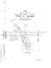
Document - Survey Plan, Country Roads Board, SP 6801, Eltham-Yarra Glen Road; Brougham St to Bridge St, 1958
... Survey Plan...Survey Plan...1958 C.R.B. Plan of Survey of Part of Crown Portion 12... melbourne Survey Plan Document SP 6801, Eltham-Yarra Glen Road ...1958 C.R.B. Plan of Survey of Part of Crown Portion 12 Section 4 Parish of Nillumbik, County of Evelyn Eltham-Yarra Glen Road, Shire of Eltham Shows Surveyor field notes, property ownership and building type and construction.a.j. collis, a.s. & c.g.h. fitzpatrick, board of land & works, bridge street, brougham steet, commonwealth bank of australia, country roads board, eltham, eltham rsl sub-branch, f.h. collis, f.m. smith, f.n. & e.j. burgoyne, franklin street, h.c. & r.e. burgoyne, j. jorgenson, j.f. & j.e. morris, j.n. & h.c. burgoyne, j.s. blow, john street, main road, p.e. smith, pitt street, r.j. dripps, s.j. taylor, survey plan, trustees of the eltham methodist church, 1958, eltham-yarra glen road, neil webster collection -
 Eltham District Historical Society Inc
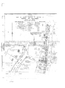
Document - Survey Plan, Country Roads Board, SP 6802, Eltham-Yarra Glen Road; Brougham St to Dalton St, 1958
... Survey Plan...Survey Plan...1958 C.R.B. Plan of Survey of Part of Crown Portion 12... melbourne Survey Plan Document SP 6802, Eltham-Yarra Glen Road ...1958 C.R.B. Plan of Survey of Part of Crown Portion 12 Section 4 Parish of Nillumbik, County of Evelyn Eltham-Yarra Glen Road, Shire of Eltham Shows Surveyor field notes, property ownership and building type and construction.1958, eltham-yarra glen road, a.f. munday, bible street, brougham steet, country roads board, dalton street, eltham, j.p. & e.a. sanders, j.w. & e. m. graham, l.c. skipper, l.m. jarrold, main road, napoleon street, survey plan, neil webster collection -
 Eltham District Historical Society Inc
Document - Survey Plan, Country Roads Board, SP 6313, Eltham-Yarra Glen Road; Luck St to Henry St, 1956
... Survey Plan...Survey Plan...1956 C.R.B. Plan of Survey of Part of Crown Portion 13... melbourne Survey Plan Document SP 6313, Eltham-Yarra Glen Road; Luck ...1956 C.R.B. Plan of Survey of Part of Crown Portion 13 Section 4 Parish of Nillumbik, County of Evelyn Eltham-Yarra Glen Road, Shire of Eltham Shows Surveyor field notes, property ownership and building type and construction.eltham-yarra glen road, country roads board, eltham, main road, survey plan, 1956, a.l. lyon, a.w. brinkkotter, arthur street, c.r. burkett, dudley street, e.n. staff, eltham war memorial trust, henry street, luck street, pryor street, the board of land & works, the equity trustees executors and agency coy ltd, the roman catholic trusts corporation, victorian railways commision, neil webster collection -
 Eltham District Historical Society Inc
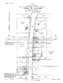
Document - Survey Plan, Country Roads Board, SP 6800, Eltham-Yarra Glen Road; Bridge St to Henry St, 1958
... Survey Plan...Survey Plan...1958 C.R.B. Plan of Survey of Part of Crown Portions 12... melbourne Survey Plan Document SP 6800, Eltham-Yarra Glen Road ...1958 C.R.B. Plan of Survey of Part of Crown Portions 12 and 13 Section 4 Parish of Nillumbik, County of Evelyn Eltham-Yarra Glen Road., Shire of Eltham Shows Surveyor field notes, property ownership and building type and construction.1958, a.m. gahan, a.s & s.j. davis, annie ellen davies, bridge street, country roads board, d.a. lyon, dave lyon, eltham, flora towell, g.e. gallagher, henry street, j. lyon, k. greene, main road, p.a. gahan, survey plan, w.l. chynoweth pty ltd, york street, neil webster collection -
 Eltham District Historical Society Inc
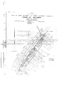
Document - Survey Plan, Country Roads Board, SP 6561, Eltham-Yarra Glen Road; Park Rd to Bellevue Rd, 1957
... Survey Plan...Survey Plan...1957 C.R.B. Plan of Survey of Parts of Crown Allotment 1... melbourne Survey Plan Document SP 6561, Eltham-Yarra Glen Road; Park ...1957 C.R.B. Plan of Survey of Parts of Crown Allotment 1 & Crown Allotment F, Section II Parish of Nillumbik, County of Evelyn Eltham-Yarra Glen Road, Shire of Eltham Shows Surveyor field notes, property ownership and building type and construction.eltham-yarra glen road, country roads board, eltham, main road, survey plan, 1957, a.r. thomas, b. & b.d. hearn, b.g. anderson, bellevue road, e.m. pitts, f.a. m. macrae, g.e. & b. moulder, j. bromley, j.m. & s.g. johnstone, k.f. pitts, l.c. docksey, m. & e.c.w. baart, m.p. bromley, n.r. ord, p.j. & g.e. murphy, park road, r.a. bruce, r.a. macbeth, r.w. shearing, railway road, s.e. & y.p. houghton, w.k. bell, w.s.r. & f.n. toley, neil webster collection -
 Eltham District Historical Society Inc
Document - Survey Plan, Country Roads Board, SP 6559-6560, Eltham-Yarra Glen Road; Elsa Ct to Luck St, 1957
... Survey Plan...Survey Plan...1957 C.R.B. Plan of Survey of Part of Crown Portion 13... melbourne Survey Plan Document SP 6559-6560, Eltham-Yarra Glen Road ...1957 C.R.B. Plan of Survey of Part of Crown Portion 13 Section 4 and Crown Allotment 1 Section 1 Parish of Nillumbik, County of Evelyn Eltham-Yarra Glen Road, Shire of Eltham Shows Surveyor field notes, property ownership and building type and construction.eltham-yarra glen road, country roads board, eltham, main road, survey plan, 1957, a.m. & a.a. iowerson, a.mcg. hepburn, cecil street, coffee lounge, diamond street, e.g. murrell, elsa court, h.b. woodhead, j.c. & s.i. harding, la ronde, luck street, r.m. & v.m. white, r.n. mowatt, the board of land & works, w.g. hains, neil webster collection -
 Federation University Historical Collection
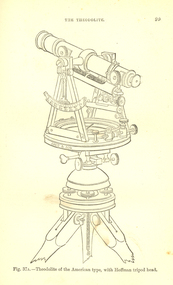
Book, Bennett H. Brough, A treatise on Mine-Surveying, 1904
... , Mine-Surveying Problems, Mine Plans, Photographic Surveying... Plans, Photographic Surveying, examination Surveying ...The author, Bennett H. Brough was an associate of theRoyal School of Mines, a member of the COuncil of the Institution of Mining Engineers, a fellow of the geological society and of the Institute of Chemistry, a member of the Mining Institute of Cornwall, and a former instructor of mine-surveying at the Royal School of MinesRed had covered book 372 pages - part of Griffin's Mining Series. Contents include general explanatinos of surveying, an historical sketch, mineral deposits, mining terms, measures of length, measurement distances, the chain, rods, steel bands, measuring wheel, Miner's Dial, Magnetic needle, Fixed needle, German Dial, theodolite, traversing underground. Surface-surveys. plotting the survey, calculation of area, leveling, Telescope, Setting out, Mine-Surveying Problems, Mine Plans, Photographic Surveying, examination Surveying. Illustrations include: Whitelaw's Dial (Fig 22), Theodolite of the American Type with Hoffman tripod head, (fig 37a)mining, surveying, miner's dial, chain, survey, theodolite, scientific instruments -
 University of Melbourne, Burnley Campus Archives
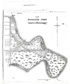
Plan - Photocopy, A.L. Martin et al, Plan of Richmond Park, 1872
... 3 photocopies of plan surveyed and drawn by A.L. Martin.... richmond parks a.l. martin 3 photocopies of plan surveyed and drawn ...Layout of Richmond Park showing railway line, Pic-Nic Station, Swan Street extension and Horticultural Society's Garden. 3 photocopies of plan surveyed and drawn by A.L. Martin, Authorised Surveyor. Photolithographed at Dept of Lands and Survey by J. Noone 6th Sept. 1872. Showing the entire park and the Horticultural Society's Garden.richmond, parks, a.l. martin -
University of Melbourne, Burnley Campus Archives
Map, Plan of Early Melbourne Showing Original Crown Allotments, c. 1852
... , and a portion of Prahran Compiled from the Government Plans and Private... the Government Plans and Private Survey by William Green.' (2 copies, one ...Copy of 'Map of the City of Melbourne, and its Extension, together with Collingwood, Richmond, Hawthorne, the Emerald Hill, and a portion of Prahran Compiled from the Government Plans and Private Survey by William Green.' (2 copies, one enlarged)melbourne, william green, richmond, hawthorne, collingwood -
University of Melbourne, Burnley Campus Archives
Work on paper (item) - Survey Plan, Thomas and George Licensed Surveyors, Partial Feature Survey Plan 125 Dee Road Millgrove 3799, 25th February, 2014
... Survey Plan...Partial Feature Survey Plan 125 Dee Road Millgrove 3799...survey plan...A sheet of paper on which a partial feature survey plan... Boulevard Richmond melbourne Survey Plan Work on paper Partial ...Prepared for building and landscape design purposes. It was created by a company called 'Thomas and George Licensed Surveyors' and the survey was conducted on the 24th February 2014. 125 dee road, millgrove, survey plan -
Glen Eira Historical Society
Plan - Warrigal Road, Oakleigh
... Survey Plan... valuation of land for proposed widening of Warrigal Road. A plan... of land for proposed widening of Warrigal Road. A plan of Survey ...Documents about a small portion of land on Warrigal Road Oakleigh, now Oakleigh East. A Letter dated 29/05/1952 from Gas and Fuel Corporation of Victoria to Mr. L.P. Simmonds requesting valuation of land for proposed widening of Warrigal Road. A plan of Survey, no.5474, for Crown portion of Parish of Moorabbin and Parish of Mordialloc for owner The Brighton Gas Coy Ltd. New Street Brighton. Mortgages to the National Mutual Life Association. A letter dated 04/06/1952 from Gas and Fuel Corporation of Victoria in reference to Warrigal Road and Centre Road from the Country Roads Board who desire to acquire the land. Handwritten calculation notes and price for valuation, most likely as an attachment to the letter dated 04/06/1952.gas and fuel corporation, warrigal road, centre road, moorabbin council, simmonds l.p, survey plan, county of bourke, the brighton gas company ltd., country roads board, the national mutual life association of australia ltd., bentleigh east -
 Federation University Historical Collection
Plan, Scarsdale County of Grenville, 1889, 26/01/1889
... Rectangular plan of a geological survey edged in masking... E.J. Barker Library (top floor) Mount Helen goldfields Plan ...Rectangular plan of a geological survey edged in masking tape. It is predominantly grey, pink and green, but has some yellow. scale is 40 chains to one inch. (see Cat. No. 1098 for report on the Parish of Scarsdale)scarsdale, grenville, krause, browns and scarsdale, mopianimum, watershed, yarrowee, woady yalloak, timber reserve, department of mines, plans, cgt, crown lands, ferdinand krause -
 Ballarat Tramway Museum
Magazine, City of Ballaarat, "my Ballarat - Summer 2016", Jan. 2017
... the results of the Lake Wendouree Master Plan Survey - includes.... Includes the results of the Lake Wendouree Master Plan Survey ...Magazine - 40 pages, centre stapled, full colour printed on white paper, titled "my Ballarat - Summer 2016", providing news, events, activities for the City of Ballarat. Includes the results of the Lake Wendouree Master Plan Survey - includes the expansion of the Ballarat Tram depot for the joint BTM - RSL Ballarat Sub-branch - Tramway and Military Interpretative Centretrams, tramways, btm, rsl, masterplan, lake wendouree, botanical gardens -
 Greensborough Historical Society
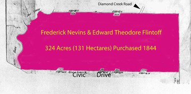
Folder of documents, Flintoff - various documents, 1844_
... in the Greensborough area. Includes a survey plan for acquisition of land... area. Includes a survey plan for acquisition of land ...Records the Flintoff family's ownership of parcels of land in the Greensborough area. Includes a survey plan for acquisition of land for the aqueduct 1897.Various photocopies of title documents relating to land owned by the Flintoff family in Greensborough.Mainly handwritten documents dating from early 20th century.flintoff family, land titles, greensborough, aqueduct -
 Kew Historical Society Inc
Plan, Melbourne & Metropolitan Board of Works : Borough of Kew : Detail Plan No.1296, 1904
... Original survey plan, issued by the MMBW to a contractor... : Detail Plan No.1296 Original survey plan, issued by the MMBW ...The Melbourne and Metropolitan Board of Works (MMBW) plans were produced from the 1890s to the 1950s. They were crucial to the design and development of Melbourne's sewerage and drainage system. The plans, at a scale of 40 feet to 1 inch (1:480), provide a detailed historical record of Melbourne streetscapes and environmental features. Each plan covers one or two street blocks (roughly six streets), showing details of buildings, including garden layouts and ownership boundaries, and features such as laneways, drains, bridges, parks, municipal boundaries and other prominent landmarks as they existed at the time each plan was produced. (Source: State Library of Victoria)This plan forms part of a large group of MMBW plans and maps that was donated to the Society by the Mr Poulter, City Engineer of the City of Kew in 1989. Within this collection, thirty-five hand-coloured plans, backed with linen, are of statewide significance as they include annotations that provide details of construction materials used in buildings in the first decade of the 20th century as well as additional information about land ownership and usage. The copies in the Public Record Office Victoria and the State Library of Victoria are monochrome versions which do not denote building materials so that the maps in this collection are invaluable and unique tools for researchers and heritage consultants. A number of the plans are not held in the collection of the State Library of Victoria so they have the additional attribute of rarity.Original survey plan, issued by the MMBW to a contractor with responsibility for constructing sewers in the area identified on the plan within the Borough of Kew. The plan was at some stage hand-coloured, possibly by the contractor, but more likely by officers working in the Engineering Department of the Borough and later Town, then City of Kew. The hand-coloured sections of buildings on the plan were used to denote masonry or brick constructions (pink), weatherboard constructions (yellow), and public buildings (grey). This area was once known as O’Shaughnessy’s Paddock. O’Shaughnessy was the licensee of the Kew Hotel. The ‘Paddock’ or farm was for many years the closest farm to Melbourne. By 1903, when this plan was surveyed and lithographed, little of the farm remained. The area is dominated by a ‘clay hole’, on the site of the current Foley Reserve. It was used by Smart’s Brickyard from the 1880s until 1911, when the Council purchased it for a rubbish dump. It is notable as the site is one of the few industrial operations to have existed in Kew. By 1903, urban development was characterised by larger houses fronting Barkers Road and brick and weatherboard villas in Foley Street. Nearer the pit, weatherboard houses predominated. Foley Street bisected the triangular block and continued right to Denmark Street. At this stage, a house impeded the through road, only allowing access via a right of way to High Street.melbourne and metropolitan board of works, detail plans, mmbw 1296, cartography